India’s villages are the heart of the nation, but for generations, one major issue remained unresolved—unclear ownership of residential properties in rural areas.
In many villages, property boundaries were based on oral traditions, local understanding, or old handwritten records, often leading to disputes, confusion, and legal complications.
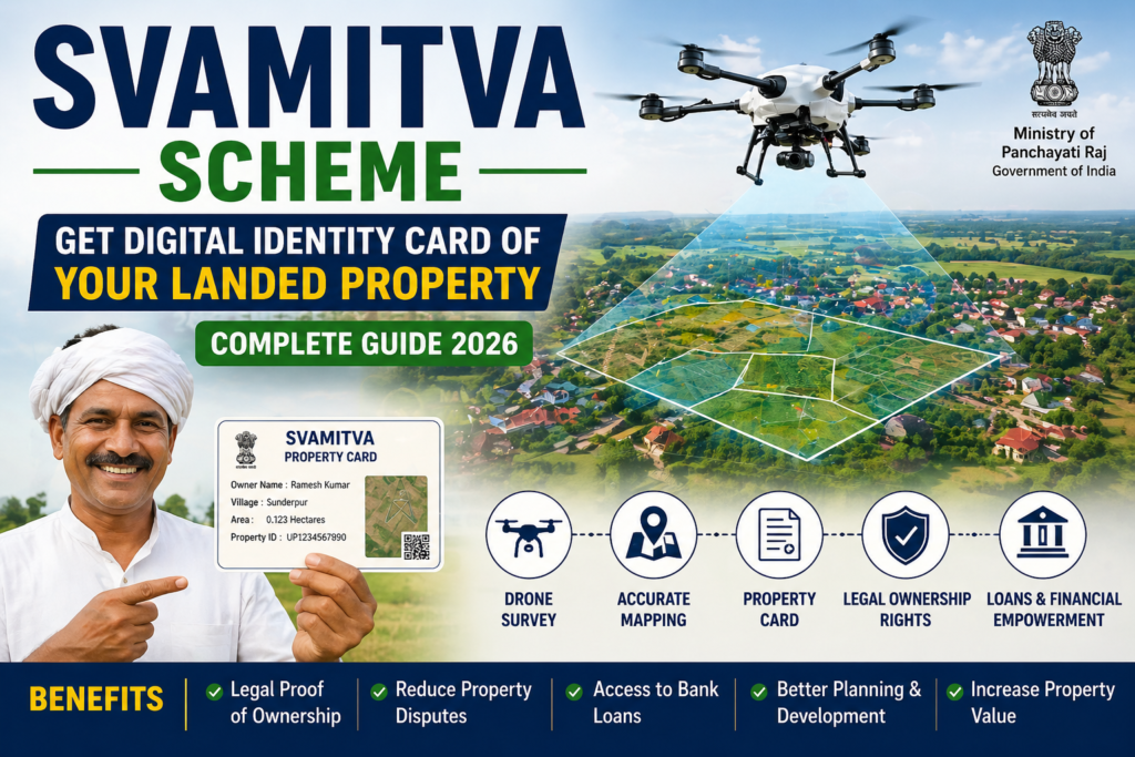
To solve this long-standing problem, the Government of India launched the SVAMITVA Scheme—a revolutionary initiative that uses drone technology and digital mapping to provide rural households with legal ownership records, known as Property Cards.
This initiative is transforming ancestral homes and land into recognized legal assets, unlocking opportunities for loans, dispute resolution, and financial empowerment.
In this article, we explain everything about SVAMITVA (Survey of Villages and Mapping with Improvised Technology in Village Areas), its benefits, objectives, and how it is changing rural India.
What is SVAMITVA?
SVAMITVA stands for:
Survey of Villages and Mapping with Improvised Technology in Village Areas
It is a Central Sector Scheme launched by the Government of India on 24 April 2020, on the occasion of National Panchayati Raj Day.
The scheme is implemented by the Ministry of Panchayati Raj in collaboration with:
- Survey of India
- State Revenue Departments
- State Panchayati Raj Departments
- National Informatics Centre (NIC)
The main aim is to provide an integrated property validation solution for rural India.
Why Was SVAMITVA Needed?
For decades, rural India faced several problems:
1. No Clear Ownership Records
Many village homes did not have official legal documents proving ownership.
2. Frequent Property Disputes
Boundary disputes among families and neighbors were common.
3. Difficulty in Getting Loans
Without legal proof of ownership, villagers could not use their property as collateral for bank loans.
4. Poor Village Planning
Lack of accurate maps made infrastructure planning difficult.
SVAMITVA addresses all these issues using modern drone and GIS technology.
How SVAMITVA Works
The implementation process includes the following steps:
1. Drone Survey
High-resolution drones fly over villages and capture aerial images.
2. GIS Mapping
The images are processed into accurate digital maps using Geographic Information System (GIS) technology.
3. Boundary Verification
Local residents and officials verify property boundaries.
4. Property Card Generation
After verification, property owners receive an official Property Card.
This card acts as legal proof of ownership.
What is a SVAMITVA Property Card?
A Property Card is a legal document containing:
- Owner’s name
- Property dimensions
- Geo-coordinates
- Unique property ID
- Official ownership details
It can be used for:
✅ Applying for bank loans
✅ Resolving disputes
✅ Selling or transferring property
✅ Legal documentation
Benefits of the SVAMITVA Scheme
The SVAMITVA scheme offers multiple benefits:
1. Legal Ownership Rights
Villagers get recognized ownership records.
2. Financial Inclusion
Property can be used as collateral for loans.
3. Reduced Disputes
Accurate maps reduce conflicts.
4. Better Tax Collection
Gram Panchayats can assess and collect property tax efficiently.
5. Improved Village Planning
Authorities can plan roads, drainage, and utilities better.
6. Digital India Push
It promotes digital governance in rural India.
Key Features of SVAMITVA
- Drone-based surveying
- High-accuracy mapping
- Digital Property Cards
- Nationwide implementation
- Integration with land records
- Empowerment of Gram Panchayats
SVAMITVA Scheme Progress
The scheme has already made significant progress across India.
Millions of rural households have received Property Cards, giving them legal recognition over their homes.
Thousands of villages have been surveyed under this scheme.
This initiative is considered one of the biggest drone-based land mapping projects in the world.
Impact on Rural Economy
SVAMITVA can transform rural India by:
- Increasing property value
- Encouraging formal credit access
- Boosting rural entrepreneurship
- Reducing legal costs
- Strengthening village-level governance
When ancestral homes become recognized legal assets, they can contribute to economic growth.
Challenges in Implementation
Despite success, some challenges remain:
- Boundary disagreements
- State-level coordination issues
- Digital literacy gaps
- Updating records regularly
The government is continuously improving implementation.
How to Check Your SVAMITVA Property Card
Villagers can check or receive updates through:
- Gram Panchayat office
- Local Revenue office
- Official state portals
- SMS / online notifications
Future of SVAMITVA
The future scope includes:
- Integration with digital land records
- Smart village planning
- Better governance systems
- Rural economic development
SVAMITVA is not just a mapping scheme—it is a digital identity revolution for rural India.
Frequently Asked Questions (FAQs)
What is SVAMITVA?
It is a drone-based rural property mapping scheme.
Who launched SVAMITVA?
The Government of India launched it in 2020.
What is a Property Card?
It is a legal ownership document for rural residential property.
Can Property Cards help in getting loans?
Yes, they can be used as collateral.
Is SVAMITVA available in all states?
The scheme is being implemented across India in phases.
Final Words
For generations, village boundaries lived in stories, traditions, and memory.
Then came SVAMITVA—a drone-led revolution that mapped the unmapped.
Today, that vision is in the hands of millions as a Property Card, converting ancestral homes into legal and financial assets.
SVAMITVA is truly giving every village home its digital identity.
Know more on this topic :
SVAMITVA Scheme, SVAMITVA Property Card, drone survey village property, rural property ownership India, digital property card India, Survey of Villages and Mapping with Improvised Technology, village property card benefits, Government schemes for villages, rural India digital identity