
Article: What do the colours of milestone stones on Indian roads mean?
What do the colours of milestones on Indian roads mean? A complete guide
Why do milestone colours matter?
India’s road network spans over 63 lakh kilometres, making it one of the largest in the world. To help commuters, drivers, and emergency services quickly identify road types and jurisdiction, the government uses a standardised colour-coding system on the kilometre stones (also called KM stones or milestones) placed every kilometre along roads.
Knowing what each colour means can help you navigate better, identify road quality expectations, and understand which authority maintains that stretch of road.
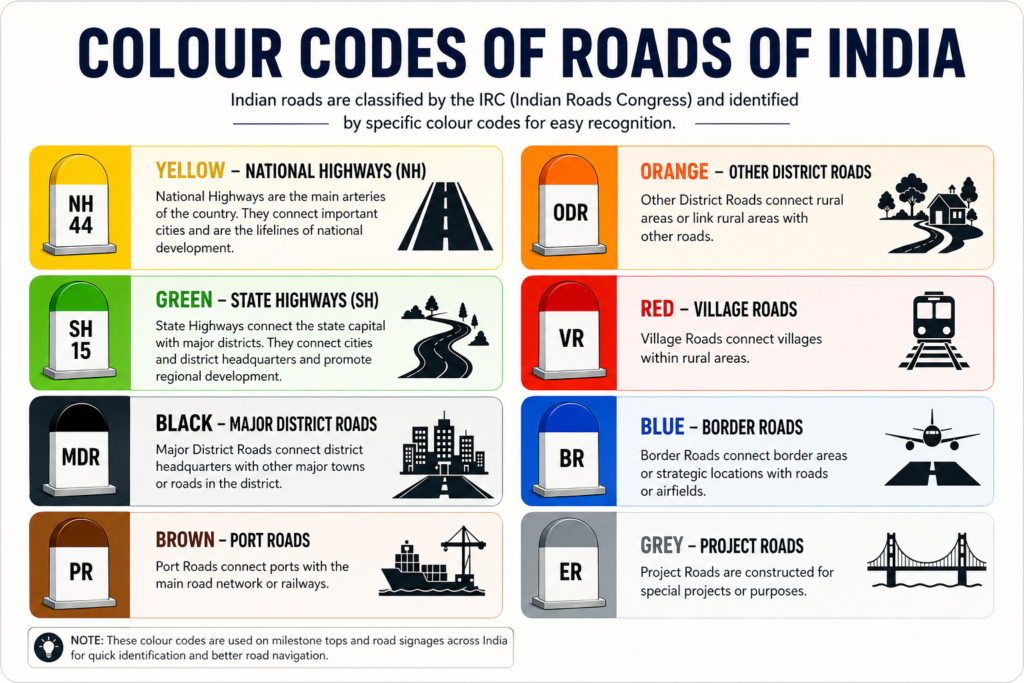
Complete colour-code reference table
| Colour | Road type | Example | Maintained by |
|---|---|---|---|
| Yellow | National Highway (NH) | NH 44 | NHAI / MoRTH |
| Green | State Highway (SH) | SH 15 | State PWD |
| Black | Urban / City road | Municipal roads | Municipal corporation |
| Orange | Rural / Village road | Gram Panchayat roads | Panchayat / PMGSY |
| Red | Railway crossing / rail line | Rail overbridge area | Indian Railways |
| Blue | Airport / aviation zone | Near airfields | AAI / Civil Aviation |
| Brown | Port / seaport zone | Near major ports | Port Authority |
| Grey | Bridge / flyover | Near bridges | Bridge authority / PWD |
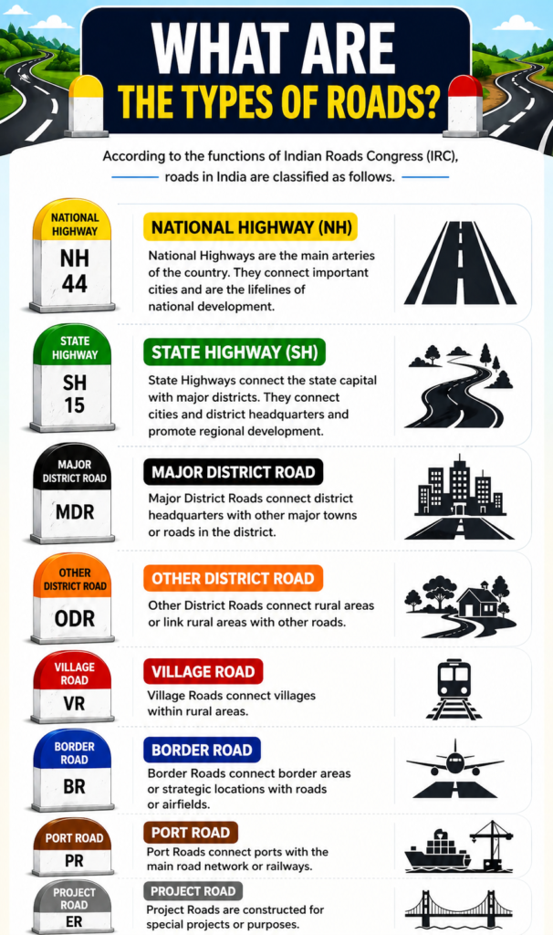
Understanding each road type in detail
Yellow — National Highways (NH): These are the most important long-distance roads of India, connecting major cities across states. They are numbered (e.g. NH 44 is the longest in India, running from Srinagar to Kanyakumari). Yellow milestones with black lettering indicate you are on a nationally significant corridor maintained by NHAI or the Ministry of Road Transport and Highways.
Green — State Highways (SH): Green milestones mark roads that connect important towns and districts within a single state. They are subordinate to National Highways in hierarchy but still carry significant inter-district traffic. State Public Works Departments (PWD) maintain these roads.
Black — Urban and city roads: Black milestones (or black-topped markers) are found within city or municipal limits. These roads fall under the jurisdiction of municipal corporations or urban local bodies, which are responsible for their upkeep and repair.
Orange — Rural and village roads: Orange stones mark rural roads, often built under the Pradhan Mantri Gram Sadak Yojana (PMGSY) scheme to connect villages to the main road network. These are typically narrower and link gram panchayats to district or state roads.
Red — Railway lines or crossings: Red-coloured markers near a road indicate proximity to railway infrastructure — level crossings, rail bridges, or railway stations. This colour serves as a visual alert for both drivers and railway staff.
Blue — Airport and aviation zones: Blue milestones are used near airports and airfields, and on roads under the jurisdiction of the Airports Authority of India (AAI) or civil aviation bodies.
Brown — Port and seaport zones: Brown stones appear near major ports and shipping yards. These roads serve heavy goods vehicles and cargo logistics and fall under port authority management.
Grey — Bridges and flyovers: Grey milestones indicate a bridge, overpass, or flyover location. They help engineers and maintenance crews locate bridge structures along a route quickly.
How milestone stones are structured
A standard Indian milestone stone typically shows the road number at the top (e.g. NH 44), the distance to the next major town, and the distance from the origin point. The colour of the stone’s top band or the entire stone body identifies the road type at a glance. Some modern milestones include retroreflective paint for visibility at night.
Frequently asked questions
- How to Improve Brain Power Naturally: 15 Science-Backed Habits to Boost Memory, Focus and Mental Performance
- Mount Kailash Mystery Explained: Why the World’s Most Sacred Mountain Remains Unclimbed
- Mastering the Art of Dangerous Confidence: Life-Changing Lessons to Build Unshakable Self-Belief
- Fueling the Mind: The Complete Guide to Brain Health, Memory and Mental Performance
- Beyond Degrees: 5 High-Growth Careers Dominating the 2026 Job Market